Deskripsi
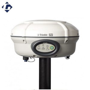
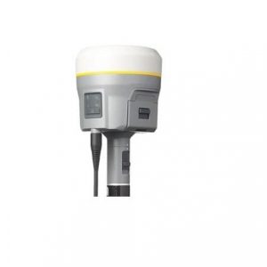
GPS GEODETIC GNSS TRIMBLE-R8
Global Positioning System (GPS) is a system for determining the position on the earth’s surface with the help of satellite signal synchronization. This system uses 24 satellites that send microwave signals to Earth. This signal is received by the receiver on the surface, and is used to determine the location, speed, direction, and time. Systems similar to GPS include Russian GLONASS, European Union Galileo, India’s IRNSS.
Through advanced Trimble 360 tracking technology and a comprehensive set of communication options integrated into a flexible system design, this integrated GNSS system delivers industry-leading performance in a rugged, compact unit.
Trimble 360 Receiver Technology:
Supports signals from all existing and planned GNSS constellations and augmentation systems. It is now possible for surveyors to expand the reach of their GNSS rovers into areas that were previously too obscured, such as under trees and in dense urban areas.
- Two integrated Trimble Maxwell 6 chips
- 440 GNSS channels
- Capable to tracking satellite systems including GPS, GLONASS, Galileo, BeiDou(COMPASS), and QZSS
- CMRx communications protocol gives you the most reliable positioning performance
Flexible System Design:
Combines the most comprehensive feature set into an integrated and flexible system design for demanding surveying applications.
- Connect directly to the controller
- Receive RTK network connections
- Connect to the Internet
- Built-in UHF Radio
- Internal NTRIP caster
Kineta Survey Jakarta is one of the businesses engaged in the sale of survey and mapping tools for Jakarta, which is located at Jl. Raya Petojo Binatu III No. 28 Kineta Jakarta, as a center for surveying and mapping tools, provides complete products such as Total Station, Digital Theodolite, GPS, Compass, Automatic Level Waterpass and others.
Kineta Survey Jakarta is the center of excellent service for survey instruments by providing quality products and official guarantees. Entrust your needs for survey and mapping tools only at Kineta Survey Jakarta.

 Contac :

Ulasan
Belum ada ulasan.