Deskripsi
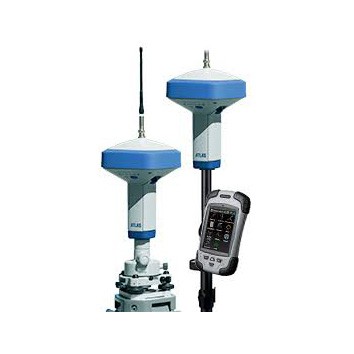
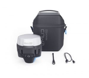
GPS GEODETIC SOKKIA GNSS-ATLAS
Global Positioning System (GPS) is a system for determining the position on the earth’s surface with the help of satellite signal synchronization. This system uses 24 satellites that send microwave signals to Earth. This signal is received by the receiver on the surface, and is used to determine the location, speed, direction, and time. Systems similar to GPS include Russian GLONASS, European Union Galileo, India’s IRNSS.
GPS GEODETIC SOKKIA GNSS-ATLAS
226 channels with optimized satellite tracking technology
Integrated full wave GNSS antenna
Internal UHF radio with optional cellular module
32GB SDHC storage support• Dual hot-swappable batterie
Spesifikasi Gps Geodetik Sokkia Atlas
Tracking Capability
Number of Channels : 226 channels with optimized satellite tracking technology
Tracked Signals
GPS: L1, L1C*, L2, L2C, L5*
GLONASS: L1, L2
Galileo*: E1, E5a, E5b, AltBOC
BeiDou: B1, B2SBAS: L1 C/A WAAS/MSAS/
EGNOSQZSS: L1 C/A, L1C*, L2
CAntenna Type : Integrated full wave GNSS antenna
Accuracy (RMS)**
RTKH: 5 mm + 0.5 ppm V: 10 mm + 0.8 ppm
Static†H: 3.0 mm + 0.1 ppm V: 3.5 mm + 0.4 ppm
Communication
Optional Radio Type Integrated UHF
Base Radio Output 1.0 W, user selectable
Optional Cellular Integrated HSPAI
/O Communications Bluetooth®RS232 serialUSB
Connectors BNC modem antennaPowerRS232 serialUSB
Data and StorageMemoryRemovable SD/SDHC Card
Data Update/Output Rate 1 Hz – 50 Hz Selectable
Real Time Data Output TPS, RTCM 2.X, RTCM 3.X, RTCM MSM, CMR, CMR+
ASCII Output NMEA 0183 version 2.x and 3.0
General
PowerBatteries: Dual rechargable external hot-swappable Li-ion, 3900 mAh, 7.2 V
External: Single power portDimensions (w x h x d )158.1 x 253 x 158.1 mm
WeightWith batteries: 1.88 kgWithout batteries: 1.44 kg
Mounting5/8-11, quick disconnect
Operating Temperature Integrated Batteries: -30ºC to 60ºCExternal Power: -40ºC to 70°C
Enclosure Dust and water ingress protected magnesium I-Beam housing
Shock Rating 2 m pole drop to concrete, IEC 60068-2-29, and IEC 60068-2-27
Vibration Rating Compliance with MIL-STD 810F – 514.5 – Cat.24
Paket Pembelia Gps Geodetik
- Base Receiver
Rover Receiver
Controller
Sertifikat Kalibrasi
Free Training & Ongkir Sejakarta
GPS GEODETIC SOKKIA GNSS-ATLAS
Kineta Survey Jakarta is one of the businesses engaged in the sale of survey and mapping tools for Jakarta, which is located at Jl. Raya Petojo Binatu III No. 28 Kineta Jakarta, as a center for surveying and mapping tools, provides complete products such as Total Station, Digital Theodolite, GPS, Compass, Automatic Level Waterpass and others.
Kineta Survey Jakarta is the center of excellent service for survey instruments by providing quality products and official guarantees. Entrust your needs for survey and mapping tools only at Kineta Survey Jakarta.

 Contac :

Ulasan
Belum ada ulasan.