Deskripsi
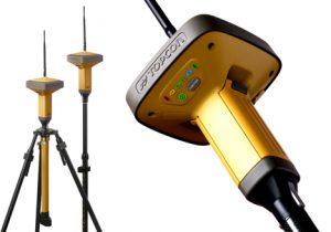
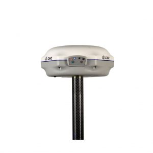
GPS GEODETIC GNSS TOPCON-GR-5
Global Positioning System (GPS) is a system for determining the position on the earth’s surface with the help of satellite signal synchronization. This system uses 24 satellites that send microwave signals to Earth. This signal is received by the receiver on the surface, and is used to determine the location, speed, direction, and time. Systems similar to GPS include Russian GLONASS, European Union Galileo, India’s IRNSS.
GPS GEODETIC GNSS TOPCON-GR-5
Teknologi internal dalam Topcon GR-5 penerima kecil dan keluar dari pandangan, namun membawa pukulan kuat dengan kemampuan untuk mendengarkan dan melacak setiap satelit yang tersedia hari ini dan besok.
GPS Topccon GR 5memanfaatkan tenaga kuda pengolahan dan kecerdasan dari 226-channel Vanguard Chip Topcon. Alih-alih tugas saluran khusus untuk melacak sinyal atau satelit tertentu, teknologi Vanguard Topcon cukup pintar untuk secara efisien mengelola setiap sinyal dari setiap konstelasi untuk Anda pada kecepatan seperti Anda belum pernah lihat sebelumnya.
Features GPS Topccon GR5
- Capable of tracking GPS, GLONASS, BeiDou, Galileo, QZSS constellations
- Universal Tracking Channels capable of all-in-view tracking
- Track every satellite constellation above today and tomorrow
- Signal scrubbing Fence Antenna® to provide ultimate signal lock
- Highest accuracy positioning for RTK, network, and more
- Offers choice of UHF or Spread Spectrum radios, as well as an optional, internal cellular modem for all your project needs
|
Specifications |
|
| TRACKING | |
| Number of Channels | 216 Universal Channels |
| Signals Tracked | G3 Technology – GPS, GLONASS and GALILEO* |
| WAAS/EGNOS/MSAS | |
| WAAS/EGNOS/MSAS | Yes |
| ACCURACY | |
| RTK | H: 10 mm + 1 ppm |
| V: 15 mm + 1 ppm | |
| Static/Fast Static | H: 3mm + 0.5ppm |
| V: 5mm + 0.5ppm | |
| COMMUNICATIONS | |
| Optional Radio Type | Integrated UHF TX/RX, or 915MHz Spread Spectrum |
| Base Radio Output | 0.01 – 1.0W, user selectable |
| Cellular Communications | Integrated GSM/GPRS or CDMA**** |
| Wireless Communications | Integrated Bluetooth® 2.0 compliant |
| DATA & MEMORY | |
| Memory | Internal, Removable SD/SDHC Memory Card |
| Data Update/Output Rate | 1Hz – 100Hz Selectable*** |
| Real Time Data Output | TPS, RTCM SC104, CMR, CMR+ |
| ASCII Output | NMEA 0183 version 2.x and 3.0 |
| ENVIRONMENTAL | |
| Enclosure | Magnesium I-Beam Housing |
| Operating Temperature | -40 to +70°C** |
| Dust/Water Protection | IP66 |
| Shock Rating | 2 meter pole drop to concrete |
| IEC 60068-2-29, IEC 60068-2-27 | |
| Vibration Rating | SAE J1211, Section 4.7 |
| MIL-STD 202G, Method 214A | |
Kineta Survey Jakarta is one of the businesses engaged in the sale of survey and mapping tools for Jakarta, which is located at Jl. Raya Petojo Binatu III No. 28 Kineta Jakarta, as a center for surveying and mapping tools, provides complete products such as Total Station, Digital Theodolite, GPS, Compass, Automatic Level Waterpass and others.
Kineta Survey Jakarta is the center of excellent service for survey instruments by providing quality products and official guarantees. Entrust your needs for survey and mapping tools only at Kineta Survey Jakarta.

 Contac :

Ulasan
Belum ada ulasan.