Deskripsi
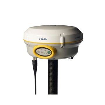
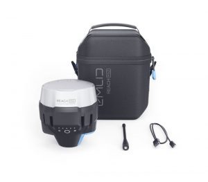
GPS GEODETIC TRIMBLE R8S
Global Positioning System (GPS) is a system for determining the position on the earth’s surface with the help of satellite signal synchronization. This system uses 24 satellites that send microwave signals to Earth. This signal is received by the receiver on the surface, and is used to determine the location, speed, direction, and time. Systems similar to GPS include Russian GLONASS, European Union Galileo, India’s IRNSS.
PERFORMANCE SPECIFICATIONS1
Measurements
multipath error, low time domain correlation and high dynamic response
• Very low noise GNSS carrier phase measurements with <1 mm precision in a 1 Hz
bandwidth
– GPS: L1C/A, L1C, L2C, L2E, L5
– GLONASS: L1C/A, L1P, L2C/A, L2P, L3
– SBAS: L1C/A, L5 (for SBAS satellites that support L5)
– Galileo: E1, E5A, E5B
– BeiDou (COMPASS): B1, B2
• SBAS: QZSS, WAAS, EGNOS, GAGAN
• Positioning rates: 1 Hz, 2 Hz, 5 Hz, 10 Hz, and 20 Hz
GPS GEODETIC TRIMBLE R8S
GPS GEODETIC TRIMBLE R8S POSITIONING PERFORMANCE2
Code differential GNSS positioning
Horizontal. . . . . . . . . . . . . . . . . . . . . . . . . . . . . . . . . . 0.25 m + 1 ppm RMS
Vertical . . . . . . . . . . . . . . . . . . . . . . . . . . . . . . . . . . . 0.50 m + 1 ppm RMS
SBAS differential positioning accuracy3. . . . . . . . . . . . . . . typically <5 m 3DRMS
Static GNSS surveying
High-Precision Static
Horizontal. . . . . . . . . . . . . . . . . . . . . . . . . . . . . . . . . . .3 mm + 0.1 ppm RMS
Vertical. . . . . . . . . . . . . . . . . . . . . . . . . . . .. . . . . . . . .3.5 mm + 0.4 ppm RMS
Static and Fast Static
Horizontal. . . . . . . . . . . . . . . . . . . . . . . . . . . . . . . . 3 mm + 0.5 ppm RMS
Vertical. . . . . . . . . . . . . . . . . . . . . . . . . . . . . . . . . . 5 mm + 0.5 ppm RMS
Postprocessed Kinematic (PPK) GNSS surveying
Horizontal. . . . . . . . . . . . . . . . . . . . . . . . . . . . . . . . . 8 mm + 1 ppm RMS
Vertical . . . . . . . . . . . . . . . . . . . . . . . . . . . . . . . . . . . .15 mm + 1 ppm RMS
Real Time Kinematic surveying
Single Baseline <30 km
Horizontal. . . . . . . . . . . . . . . . . . . . . . .. . . . . . . . . . 8 mm + 1 ppm RMS
Vertical. . . . . . . . . . . . . . . . . . . . . . . . . . . . . . . . . . .15 mm + 1 ppm RMS
Network RTK4
Horizontal. . . . . . . . . . . . . . . . . . . . . . . . . . . . . . . . . .. . 8 mm + 0.5 ppm RMS
Vertical. . . . . . . . . . . . . . . . . . . . . . . . . . . . . . . . . . . . . 15 mm + 0.5 ppm RMS
Initialization time5. . . . . . . . . . . . . . . . . . . . . . . . . . . . . . . typically <8 seconds
Initialization reliability5. . . . . . . . . . . . . . . . . . . . . . . . . . . . typically >99.9%
HARDWARE
Physical
Dimensions . . . . . . . . . . . . 19 cm x 10.4 cm (7.5 in x 4.1 in), including connectors
Weight. . . . . . . . .1.52 kg (3.35 lb) with internal battery, internal radio and antenna
3.81 kg (8.40 lb) items above plus range pole,controller & internal radio
Operating Temperature6. . . . . . . . .. . . . . . . –40 °C to +65 °C (–40 °F to +149 °F)
Storage Temperature. . . . . . . . . . . . . . . . .. .–40 °C to +75 °C (–40 °F to +167°F)
Humidity. . . . . . . . . . . . . . . . . . . . . . . . . . . . . . . . . . .100%, condensing
Ingress Protection . . . . . . . . . . . . . . . IP67 dustproof, protected from temporary
immersion to depth of 1 m (3.28 ft)
Shock and vibration. . . . . . . . . . . . . . . . . . . . . . . . Tested and meets the following
environmental standards:
Shock. . . . . . . . . . . . . . . . . . Non-operating: Designed to survive a 2 m (6.6 ft) pole
drop onto concrete. Operating: to 40 G, 10 msec, sawtooth
Vibration. . . . . . .. . . . . . . . . . . . . . . . . . . MIL-STD-810F, FIG.514.5C
ELECTRICAL
• Power consumption is <3.2 W in RTK rover mode with internal radio and Bluetooth® in use7
• Operating times on internal battery8:
–– 450 MHz receive only option . . . . . . . . . . . . . . . . . . . . . . . . . .5.0 hours
–– 450 MHz receive/transmit option (0.5 W) . . . . . . . . . . . . . . . . . . . . 2.5 hours
–– Cellular receive option . . . . . . . . . . . . . . . . .. . . . . . . . . . . . . . . . . .4.0 hours
COMMUNICATIONS AND DATA STORAGE
• Serial: 3-wire serial (7-pin Lemo) on Port 1; full RS-232 serial (Dsub 9 pin) on Port 2
• Radio Modem1: fully Integrated, sealed 450 MHz wide band receiver/transmitter with frequency range of 403 MHz to 473 MHz, support of Trimble, Pacific Crest, and SATEL
radio protocols:
–– Transmit power: 0.5 W
–– Range: 3–5 km typical / 10 km optimal9
• Cellular1:
fully integrated, sealed internal GSM/GPRS/EDGE/UMTS/HSPA+ modem
option. CSD (Circuit-Switched Data) and PSD (Packet-Switched Data) supported.
Global Operation:
–– Penta-Band UMTS/HSPA+ (850/800, 900, 1900, and 2100 MHz)
–– Quad-Band GSM/CSD & GPRS/EDGE (850, 900, 1800, and 1900 MHz)
• Bluetooth: fully integrated, fully sealed 2.4 GHz communications port (Bluetooth)10
• External communication devices for corrections supported on Serial and
Bluetooth ports
• Data storage: 56 MB internal memory, 960 hours of raw observables
(approx. 1.4 MB/day), based on recording every 15 sec from an average of 14 satellites
Data Formats
• CMR+, CMRx, RTCM 2.1, RTCM 2.3, RTCM 3.0, RTCM 3.1 inputs and outputs
• 23 NMEA outputs, GSOF, RT17 and RT27 outputs, supports BINEX and smoothed carrier
WebUI
Certifications
FCC Part 15 (Class B device), Part 15.247 and Part 90; ICES-003, RSS-210 and RSS-119;CE Mark; C-Tick; Bluetooth EPL
Kineta Survey Jakarta is one of the businesses engaged in the sale of survey and mapping tools for Jakarta, which is located at Jl. Raya Petojo Binatu III No. 28 Kineta Jakarta, as a center for surveying and mapping tools, provides complete products such as Total Station, Digital Theodolite, GPS, Compass, Automatic Level Waterpass and others.
Kineta Survey Jakarta is the center of excellent service for survey instruments by providing quality products and official guarantees. Entrust your needs for survey and mapping tools only at Kineta Survey Jakarta.

 Contac :

Ulasan
Belum ada ulasan.